Nicht kategorisierte Dateien
Zur Navigation springen
Zur Suche springen
Unten werden bis zu 100 Ergebnisse im Bereich 1 bis 100 angezeigt.
Zeige (vorherige 100 | nächste 100) (20 | 50 | 100 | 250 | 500)
 170 Hügeli.png 1.048 × 703; 1,04 MB
 2.41 Werkstatt.jpg 2.266 × 2.129; 1,77 MB
 20140611 Varna 08.jpg 2.976 × 3.968; 2,72 MB
 30-cm-Dolch aus Maikop.png.png 792 × 206; 59 KB
 3600-2800.png 679 × 320; 95 KB
 3600-3000.png 681 × 323; 86 KB
 3600-3200.png 689 × 316; 80 KB
 3600-3400.png 689 × 321; 74 KB
 3600-3500.png 690 × 325; 70 KB
 4.81 Blasebalg.jpg 3.348 × 1.892; 1,45 MB
 5.1 Meilertypen.jpg 1.774 × 2.015; 535 KB
 5.30 Kohllösch.jpg 1.181 × 1.090; 318 KB
 5.31 Kohleausbeute.jpg 797 × 719; 241 KB
 5. Urbar Nußdorf.png 547 × 857; 807 KB
 5200-4650 cal BC.jpeg 928 × 809; 147 KB
 5800-5200 cal BC.jpeg 925 × 815; 161 KB
 6.15 Glühfarben.jpg 1.883 × 748; 217 KB
 6.2 Knickdüse.jpg 1.356 × 1.422; 365 KB
 65 Millionen Jahre Klimaentwicklung.png 808 × 490; 131 KB
 7.14 Blasebalggebrauch.jpg 1.056 × 886; 297 KB
 7.4 Tonmantel auf Kuhorn.jpg 988 × 1.181; 325 KB
 ATARHOF.jpg 4.078 × 2.354; 2,79 MB
 Abflussrinne Bodensee.png 1.684 × 860; 1,09 MB
 Abrogans - Beispiel.png 1.124 × 752; 729 KB
 Absolutchronologie.png 1.309 × 899; 220 KB
 Abstammungs-Szenario.jpg 3.404 × 1.936; 615 KB
 Abtsdorf2.png 1.739 × 574; 910 KB
 Abtsdorf I.png 846 × 859; 541 KB
 Abtsdorf II.png 766 × 804; 519 KB
 Abtsdorf III.png 853 × 878; 552 KB
 Abtsdorf Ia.jpeg 1.103 × 200; 93 KB
 Adalbert und Theodora Kottulinsky 1902.jpg 1.165 × 1.682; 590 KB
 Aerar im Attergau 1904.png 600 × 456; 511 KB
 Aksu (2002).png 581 × 648; 109 KB
 Aksu (2022).png 923 × 659; 319 KB
 Alfred Marxer Pfahlbau-Ansiedlung.png 875 × 662; 728 KB
 Alter Pfahlbau-Stationen Keutschacher See.png 1.221 × 322; 27 KB
 Alter der Pfahlbaustationen-Grafik.png 1.535 × 751; 65 KB
 Alter der Pfahlbaustationen.png 688 × 853; 94 KB
 Alter der Pfahlbaustationen endg.png 688 × 853; 94 KB
 Altheim-Mondsee 37. Jh..png 397 × 490; 348 KB
 Altheimgebiet.png 382 × 220; 38 KB
 AncientGenomes.png 1.362 × 909; 154 KB
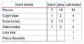 Angebrannte Fischknochen.png 474 × 247; 23 KB
 Anpflanzung im Topf 3.9.2019.jpg 2.428 × 1.003; 1,19 MB
 Ansicht Kammer.png 920 × 642; 1,47 MB
 Antl-Weiser Kalibrierte C14-Daten.png 636 × 800; 67 KB
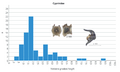 Anzahl der Cyprinidae mit Wirbelgrößen.png 1.021 × 609; 108 KB
 Anzahl gefundener Froschknochen.png 1.397 × 835; 302 KB
 Arch. DI Walter Höller.jpg 1.024 × 684; 129 KB
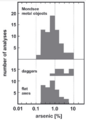 Arsengehalt Mondseer Kupfer.png 337 × 469; 61 KB
 Atmosphärischer Δ-C14-Gehalt nach Jahren.png 1.096 × 513; 90 KB
 Attersee-Besatz.png 1.055 × 635; 35 KB
 Attersee-Einzugsgebiet.png 765 × 434; 95 KB
 Attersee-Hochwasser 1899.png 989 × 620; 80 KB
 Attersee-Längsprofil.png 1.634 × 201; 287 KB
 Attersee-Querprofile.png 1.669 × 430; 578 KB
 Attersee-See-Ende.png 529 × 212; 90 KB
 Attersee Niedrigwasser 2018.png 1.034 × 580; 737 KB
 Attersee Unter Wasser.jpg 500 × 375; 61 KB
 Attersee und Attergau Vischer 1677.png 1.009 × 785; 1,3 MB
 Auerochse.png 1.437 × 758; 378 KB
 Aufham.png 772 × 834; 521 KB
 Aufham2.png 1.569 × 619; 1,3 MB
 Ausleitung „Kletzlmühle“.png 1.043 × 523; 754 KB
 Ausschnitt Eiszeitkarte.png 1.300 × 419; 1,3 MB
 Badesteg Roider.jpg 4.080 × 3.060; 4 MB
 Bamberger Dom.JPG 2.560 × 1.883; 824 KB
 Bathymetrische Karte des Mondsees.png 1.089 × 833; 912 KB
 Bauernkrieg in OÖ 1626.png 648 × 1.112; 1,47 MB
 Baugeschichte 01.png 1.653 × 2.338; 751 KB
 Baugeschichte 02.png 2.338 × 1.653; 367 KB
 Baugeschichte 03.png 2.338 × 1.653; 371 KB
 Baugeschichte 04.png 2.338 × 1.653; 372 KB
 Baugeschichte 05.png 1.653 × 2.338; 979 KB
 Baugeschichte 06.png 1.653 × 2.338; 1,24 MB
 Baugeschichte 07.png 1.653 × 2.338; 1,06 MB
 Baugeschichte 08.png 1.653 × 2.338; 272 KB
 Baugeschichte 09.png 1.653 × 2.338; 679 KB
 Baugeschichte 10.png 1.653 × 2.338; 1,17 MB
 Baugeschichte 11.png 1.653 × 2.338; 987 KB
 Baugeschichte 12.png 1.653 × 2.338; 691 KB
 Baugeschichte 13.png 1.653 × 2.338; 1 MB
 Baum.png 396 × 320; 17 KB
 Bayrische Seen.png 857 × 600; 900 KB
 Beuschl am Kronberg.png 699 × 371; 356 KB
 Bielersee-Korrektion.png 662 × 786; 165 KB
 Bild 1647 Schloss.jpg 900 × 434; 202 KB
 Bild 1672.png 983 × 593; 581 KB
 Birrfeld-Gletscher.png 1.073 × 769; 1,02 MB
 Blatt 65 Mondsee 66 Gmunden.png 386 × 287; 86 KB
 Blei-Isotopen-Analyse Schweiz 1.jpeg 1.347 × 870; 169 KB
 Blei-Isotopen-Verhältnisse.png 536 × 389; 73 KB
 Bleiisotopen-Zusammensetzung.jpeg 442 × 380; 42 KB
 Bodensee-Ausrinn.png 830 × 455; 779 KB
 Bodensee-Besiedlung.png 1.205 × 680; 959 KB
 Bodensee-Rhein-Geologie.png 1.786 × 913; 3,54 MB
 Bodenseepegel im Holozän.png 823 × 767; 604 KB
 Bronze-Nasenringe-Maryinskaya5.png 1.339 × 618; 337 KB
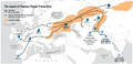 Bronzezeitliche Ausbreitung der Yamnaya-Steppenpastoralisten.png 1.059 × 509; 194 KB


.png)
.png)


Zeige (vorherige 100 | nächste 100) (20 | 50 | 100 | 250 | 500)