Datei:Plan von Hornstaad-Hörnle IA.jpeg
Version vom 5. Juni 2022, 21:26 Uhr von Admin (Diskussion | Beiträge) (Plan of Hornstaad-Hörnle IA, showing the construction dates of houses built before the fire in 3910 cal BC Quelle: Amy Styring, Ursula Maier, Elisabeth Stephan, Helmut Schlichtherle and Amy Bogaard (2016). Cultivation of choice: new insights into farming practices at Neolithic lakeshore sites. Antiquity, 90, pp 95-110 License: Creative Commons Attribution licence (http://creativecommons.org/licenses/by/4.0/),)

Größe dieser Vorschau: 800 × 570 Pixel. Weitere Auflösungen: 320 × 228 Pixel | 1.063 × 758 Pixel.
Originaldatei (1.063 × 758 Pixel, Dateigröße: 307 KB, MIME-Typ: image/jpeg)
Beschreibung
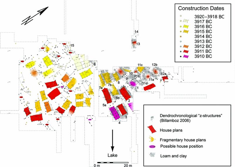
Plan of Hornstaad-Hörnle IA, showing the construction dates of houses built before the fire in 3910 cal BC
Quelle: Amy Styring, Ursula Maier, Elisabeth Stephan, Helmut Schlichtherle and Amy Bogaard (2016). Cultivation of choice: new insights into farming practices at Neolithic lakeshore sites. Antiquity, 90, pp 95-110
License: Creative Commons Attribution licence (http://creativecommons.org/licenses/by/4.0/),
Dateiversionen
Klicke auf einen Zeitpunkt, um diese Version zu laden.
| Version vom | Vorschaubild | Maße | Benutzer | Kommentar | |
|---|---|---|---|---|---|
| aktuell | 21:26, 5. Jun. 2022 | | 1.063 × 758 (307 KB) | Admin (Diskussion | Beiträge) | Plan of Hornstaad-Hörnle IA, showing the construction dates of houses built before the fire in 3910 cal BC Quelle: Amy Styring, Ursula Maier, Elisabeth Stephan, Helmut Schlichtherle and Amy Bogaard (2016). Cultivation of choice: new insights into farming practices at Neolithic lakeshore sites. Antiquity, 90, pp 95-110 License: Creative Commons Attribution licence (http://creativecommons.org/licenses/by/4.0/), |
Du kannst diese Datei nicht überschreiben.
Dateiverwendung
Die folgende Seite verwendet diese Datei: